
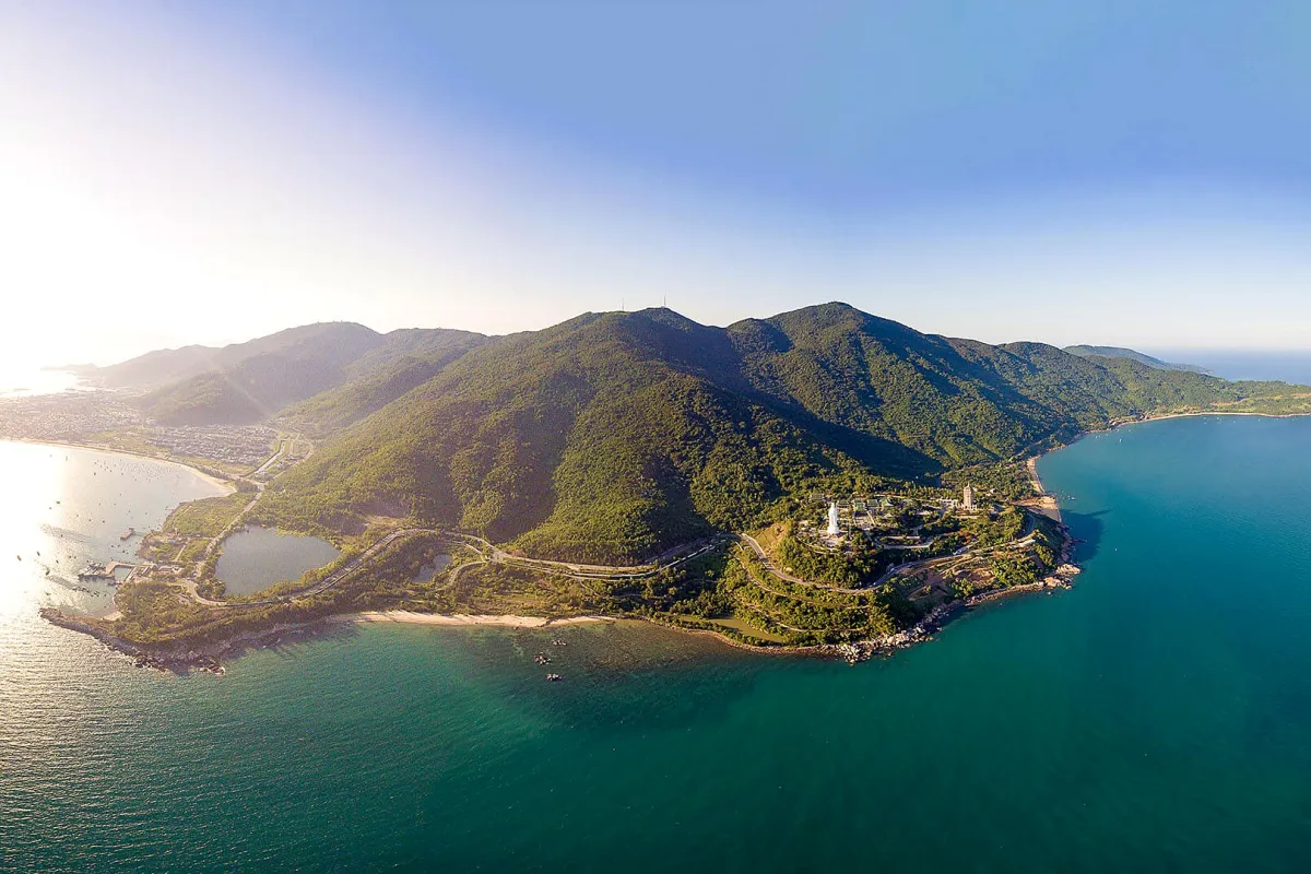
Son Tra Peninsula (bán đảo Sơn Trà), also called Monkey Mountain in English, is the forested mountain on Da Nang's northeast edge. It is home to the white Lady Buddha statue at Linh Ung Pagoda and to a rare monkey, the red-shanked douc langur. Its forest roads reopened in September 2025 after almost three years of landslide closures. One route has stayed closed since the storms of late 2025, and travel pages still suggest snorkeling at Cape Nghe, paragliding and jungle treks, which are off-limits, suspended or unlicensed. So when can you go, which roads can you ride, and which places should you stay away from?
How to plan a trip to Son Tra Peninsula
Decide first whether you want just the coast road and the Lady Buddha or also the forest roads up to Ban Co Peak, where the management board sets opening hours and vehicle rules. Son Tra's forest routes are open from 7:30 am to 5:30 pm from October to February and from 7:30 am to 6:30 pm from March to September. Automatic scooters are banned on the roads up to Ban Co Peak.
The peninsula lies about 10 km (6 miles) northeast of the city center, according to the peninsula's management board and the city's tourism portal, Danang Fantasticity. The portal's suggested itineraries take about 3 to 5 hours for a half day and 6 to 8 hours for a full day. It advises going in the morning or afternoon to avoid the strongest sun.
From October to February, the rainy season, the portal warns of heavy rain, slippery roads and thick fog, and it recommends visiting in the dry season and avoiding stormy days. See the best time to visit Da Nang for the seasons month by month.
Opening hours, routes and which vehicles are allowed
The board, whose full name is the Son Tra Peninsula and Da Nang Tourist Beaches Management Board, controls the forest routes from checkpoints. Outside opening hours the barriers are locked, and visits can be stopped when there is a dangerous weather warning. Individual visitors get a green card at the checkpoint and must hand it back to staff the same day. It is a control card, and none of the official notices cited here mention an entry fee.
| Route | Status | Allowed |
|---|---|---|
| Tien Sa – Suoi Om – Ban Co Peak | Closed | When open: bicycles, geared motorbikes, walkers |
| Yet Kieu – Ban Co Peak | Open | Cars, geared motorbikes; bicycles: reports differ |
| Ban Co Peak – Bac Beach junction | Open, one way down | Cars, geared motorbikes |
| Bac Beach junction – Heritage Banyan Tree | Open | Walkers only |
Automatic scooters and vehicles with more than 24 seats are banned on every route above. The table follows VietnamPlus, the national news agency's site, which set out the board's rules section by section on August 17, 2026, four days after the Van Hoa newspaper's report of August 13, 2026. Both said the Tien Sa route was still closed after the storms of late 2025, and as of October 2, 2026, the Van Hoa newspaper had reported no reopening. The Bac Beach junction is in front of the InterContinental resort gate.
The two reports differ on one point. VietnamPlus applies the one-way rule and the bicycle ban only to the section from Ban Co Peak down to Bac Beach. Van Hoa describes the whole Yet Kieu – Ban Co Peak – Bac Beach route as one way and closed to bicycles. Plan a loop: go up from Yet Kieu Street, come down to Bac Beach and return along Hoang Sa Street. Neither report allows bicycles on the way down to Bac Beach, so if you are cycling, ask at the Yet Kieu checkpoint whether you may ride up to the peak and back the same way.
Cars are allowed on the road up from Yet Kieu Street, so a taxi, a Grab car or a car with a driver can take you to Ban Co Peak. If you rent a motorbike for the climb, ask for a geared bike that you shift with your foot (xe số in Vietnamese), not a twist-and-go scooter. Take one only if you have ridden one before, as the roads are steep, with blind curves; the motorbike rental guide covers the license rules. None of these notices restricts scooters on Hoang Sa Street, the coast road that passes the Lady Buddha.
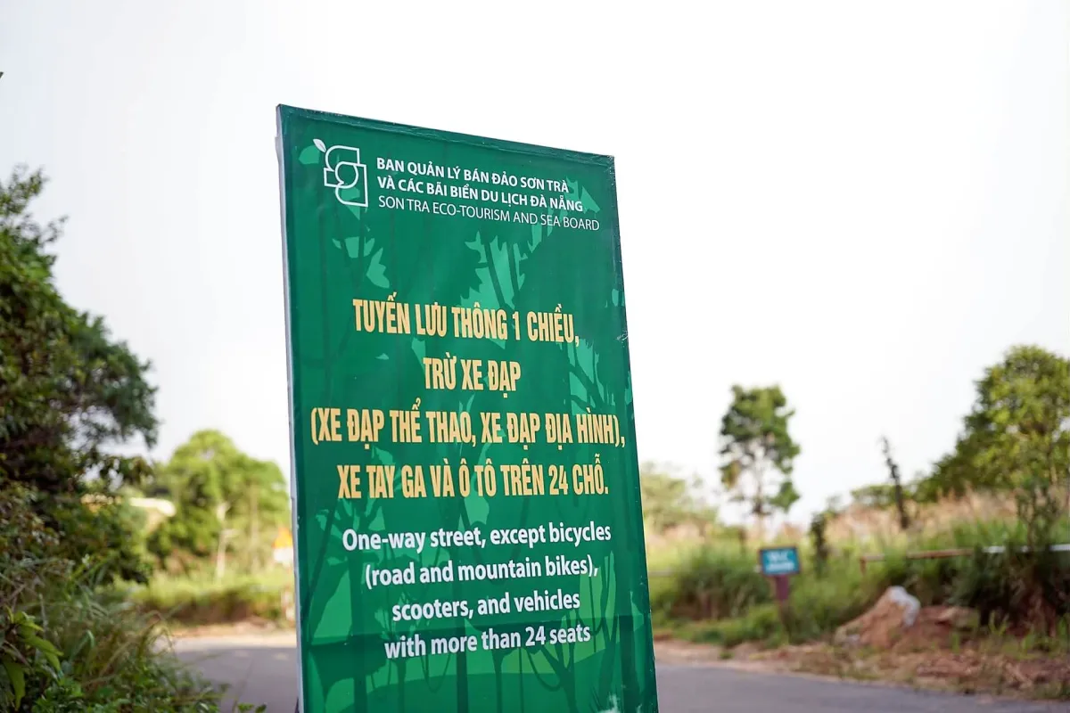
The tourism portal's main page on the peninsula, published in August 2025, still describes the earlier route rules, with vehicles allowed to the banyan tree and a route from Yet Kieu to Suoi Om. The 2026 notices above are newer and come directly from the board, so this guide follows them.
The board closes the peninsula for storms. It stopped all visits from 1:00 pm on September 27, 2025 for Typhoon Bualoi and reopened on September 30. On November 4, 2025 it kept every road closed because of heavy rain and the approaching Typhoon Kalmaegi, then reopened two routes at 7:30 am on November 8. In the rainy season, check for closures with the board's hotline, +84 236 2218 878, before you set off.
Linh Ung Pagoda and the Lady Buddha
Linh Ung Pagoda (chùa Linh Ứng Bãi Bụt) stands at Bai But, on the peninsula. Building started on July 4, 2004 and the pagoda was inaugurated on July 30, 2010. Its statue of Quan The Am, the Goddess of Mercy, is 67 meters tall on a lotus base 35 meters across; the tourism portal notes it was first planned at 32 meters.
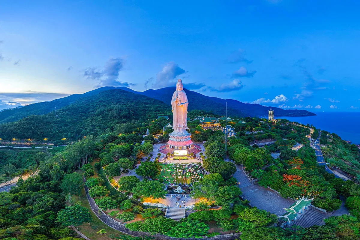
The pagoda's own website asks visitors to:
- park where the guards direct, as no cars, scooters or motorbikes may drive into the pagoda grounds;
- dress modestly, take off your shoes and keep your voice down in the main hall, and not smoke or light too many incense sticks; robes are provided at the entrance;
- not feed or approach the monkeys that come into the grounds;
- watch your belongings.
The website does not list opening hours or an entry fee; a 2016 page on the tourism portal listed entry as free and the pagoda as open all day. The city government's undated attractions page says the statue has 17 levels inside, from which visitors can admire the view; the tourism portal's page, updated in July 2023, says 12. The pagoda's own website does not mention going inside, so ask at the pagoda before you plan on it.
Ban Co Peak, the Heritage Banyan Tree and the langurs
At Ban Co Peak, you leave your vehicle and climb a steep staircase to a stone chessboard and a statue of a seated old immortal, with a view over the city. Official sources give its height differently: 630 meters in a 2019 board page and 700 meters on the tourism portal in 2025. The peninsula's highest point is 696 meters.
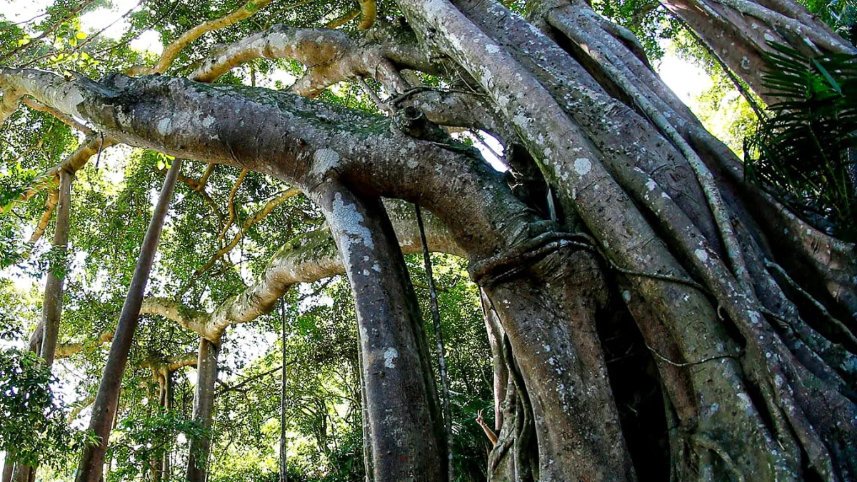
The Heritage Banyan Tree is a walk from the Bac Beach junction, since the path is open to walkers only. The Vietnam Association for Conservation of Nature and Environment named it a heritage tree on June 8, 2014, and the tourism portal says it is more than 800 years old. The August 2026 Van Hoa and VietnamPlus reports and the tourism portal's Son Tra pages do not say how long the walk is.
About 1,300 red-shanked douc langurs live on the peninsula. A 2017 survey estimated 1,335 animals, and the Van Hoa newspaper still gave a figure of more than 1,300 in September 2025; older pages that say "nearly 300" use an outdated count. The species is listed as endangered in Vietnam's Red Book and as critically endangered on the IUCN Red List. Langurs feed mainly on leaves during the day.
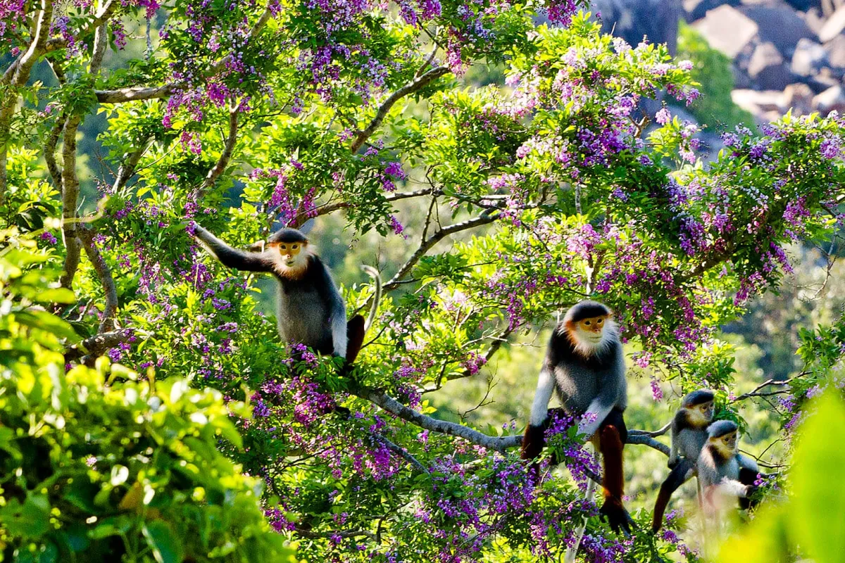
Do not feed langurs or monkeys; the tourism portal asks visitors to stay quiet and watch from a distance. Signs along the roads ban feeding monkeys, which come down to the road near Mieu Doi on Le Van Luong Street looking for food.
On September 10, 2026, the board said the Son Tra nature reserve still has no approved ecotourism plan. Entering the special-use forest to trek or watch wildlife without permission is against the law, and the board warns in particular against night treks and night wildlife watching. It asks visitors not to sign up for, buy or join trekking, eco or wildlife-watching tours whose legal status is unclear, and to report them to the board. If a "jungle trek" or "night langur tour" sold online goes into the forest, skip it and stay on the open routes.
Places you cannot go and other safety rules
Stay out of military and restricted zones, unofficial trails and the danger spots the board names, such as Cape Nghe (Mũi Nghê), Ghenh Bang (Ghềnh Bàng) and Black Stone Beach (Bãi Đá Đen). Self-guided treks down to these spots and to Huc Lo (Hục Lỡ) are banned outright. On August 8, 2026, four of a group of six were swept into the sea while taking photos at Cape Nghe. On the night of August 11, 2026, a student taking photos near the InterContinental fell into a ravine about 100 meters from the road and had to be rescued.
Some travel pages still suggest snorkeling or diving at Cape Nghe and swimming at Black Stone Beach. The board has asked tour companies not to sell diving or coral-viewing trips in areas where they are not allowed. Cape Nghe and Black Stone Beach are among the places it tells visitors to stay away from.
Paragliding on Son Tra has been suspended since a fatal accident in early July 2025. On July 23, 2026, Da Nang's Department of Culture, Sports and Tourism said no permission had been given to restart, so do not book a paragliding flight there unless a later notice from the city allows it. Do not fly a drone, film or take photos in banned or military areas without the authorities' approval.
The roads are steep, with sharp bends and blind curves. The board asks walkers to keep to the edge of the road and never step into it for a photo, and cyclists to control their speed downhill. Avoid the peninsula in heavy rain, strong wind or thick fog. Parts of Hoang Sa Street often suffer landslides after long rain, and the board warns visitors away from rocks and the shoreline when waves are high.
Only swim where lifeguards are on duty, inside the buoys or between red and yellow flags. The board's website lists the five tourist beaches it manages: Nam O, Xuan Thieu, Pham Van Dong, My Khe and Non Nuoc. None is on the peninsula. From October 1, 2026 to March 14, 2027, lifeguards at those beaches work from 5:00 am to 6:30 pm, and you should leave the water when their shift ends. For a beach with lifeguards, see My Khe Beach. The board's rescue hotline is +84 236 2218 878.
Getting there
You can get there by motorbike, Grab, taxi or a car with a driver. Hoang Sa Street runs along the coast past Linh Ung Pagoda to the Bac Beach junction, and the route up to Ban Co Peak starts from Yet Kieu Street. To show a driver where you want to go, use the Vietnamese names: Chùa Linh Ứng Bãi Bụt (Linh Ung Pagoda), Đỉnh Bàn Cờ (Ban Co Peak) and Ngã ba Bãi Bắc, cổng InterContinental (the Bac Beach junction at the InterContinental gate, where the walk to the Heritage Banyan Tree starts).
Son Tra is now the name of a ward as well as the peninsula. Since July 2025 the pagoda and the peninsula have been in Son Tra ward, which took in the old Tho Quang ward; older pages say Tho Quang ward, Son Tra district. The guide to Da Nang's districts and wards explains the change, and things to do in Da Nang lists other sights.
Sources and how we checked
We checked every time, date and rule on October 2, 2026. Opening hours, route rules, closures, banned areas and safety advice come from the management board's notices as reported by the Van Hoa newspaper and VietnamPlus between September 2025 and October 2026, and from Danang Fantasticity, the city's tourism portal. Pagoda rules come from the pagoda's own website, dates and sizes from the board's and the tourism portal's pages, and the langur count from the 2017 survey as reported by the press. Where sources disagree, on the route rules, the height of Ban Co Peak, the number of langurs and the number of levels inside the Lady Buddha, we give both, and say which is newer where both are dated. On October 2, 2026, we also looked for news of the Tien Sa route reopening, on the Van Hoa newspaper's Son Tra Peninsula topic page and in a web search, and found none. Nor did we find a report of paragliding restarting, or an official source from 2025 or 2026 on whether visitors can go inside the Lady Buddha statue.
- Van Hoa newspaper (in Vietnamese): routes, hours and banned areas (August 13, 2026); routes reopen (September 15, 2025); green cards and route rules (October 4, 2025); closure for Typhoon Bualoi (September 27, 2025); reopening (September 30, 2025); closure before Typhoon Kalmaegi (November 4, 2025); two routes reopen (November 7, 2025); unlicensed trekking tours (September 10, 2026); road safety (September 28, 2026); accident at Cape Nghe (August 8, 2026); fall near the InterContinental (August 12, 2026); paragliding suspended (July 23, 2026); langurs (September 30, 2025); feeding monkeys (April 4, 2026); beach safety in the low season (October 2, 2026).
- VietnamPlus (in Vietnamese): the three permitted routes (August 17, 2026).
- Vietnam National Authority of Tourism: Da Nang places to visit (undated, checked October 6, 2026), for the English name Monkey Mountain.
- Danang Fantasticity: The Son Tra Peninsula (August 18, 2025); Son Tra Peninsula (in Vietnamese, August 5, 2025, updated March 15, 2026); suggested itineraries (in Vietnamese, March 31, 2026); Linh Ung Pagoda (updated July 19, 2023); Linh Ung Pagoda visitor details (January 15, 2016, updated October 11, 2024); red-shanked douc langurs (in Vietnamese, September 20, 2024); do not feed the monkeys (in Vietnamese, August 24, 2024); advisory on unauthorized tours (September 11, 2026).
- Son Tra Peninsula management board (in Vietnamese, 2019 pages): general information; Ban Co Peak; Heritage Banyan Tree; Linh Ung Pagoda.
- Da Nang city government, attractions page: Linh Ung Pagoda, Son Tra Peninsula (undated; archived copy, the live page returned an error on October 6, 2026).
- Linh Ung Pagoda: pagoda website and visitor rules.
- IUCN Red List: red-shanked douc langur (assessment published 2020).
- SGGP newspaper (in Vietnamese): 2017 langur survey (May 22, 2017).
- Photos: Danang Fantasticity, Son Tra Peninsula (August 5, 2025); visitors after the routes reopened (October 8, 2025); Son Tra and My Son on The Times' list of beautiful places in Vietnam (in Vietnamese, September 11, 2026).
Updated: October 6, 2026